
| Home Page | Overview | Site Map | Index | Appendix | Illustration | Preface | Contact | Update | FAQ |
|
The terrestrial (inner) planets are composed mostly of rock and metal. As shown in Figure 07-05, Earth is the largest of the inner planets, followed by Venus, Mars, Mercury and the Moon. The interior of the Earth consists of an Fe-Ni core below a mantle of silicate rock. A comparison shows that Venus and Mars have a comparatively similar rock-iron distribution. The Moon has a much smaller core, whereas Mercury, although it is small enough to fit in the Earth's core, has a relatively large iron core. Mercury and the Moon have a large surface temperature variation between night and day. It is the result of these objects' small mass, which can barely retain a thin atmosphere. The Moon is the only celestial object that has been visited by human. |
Figure 07-05 The Terrestrial Planets |
 |
|
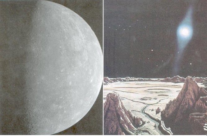
Figure 07-06a Mercury |
with time as gases are lost and replenished, because Mercury's gravitational pull cannot hold on to the gases. The artist's drawing shows the glare of the sun dominates the scorched landscape of Mercury. |
 |
The January, 2008 flyby of the MESSENGER spacecraft has captured the most recent image of Mercury (Figure 07-06b) revealing many previously unknown or unconfirmed features. There is a large impact basins created during the early history of the solar system by the impact of a large asteroid-sized body. The orange splotches around the basin's perimeter are now thought to be volcanic vents, new evidence that Mercury's smooth plains are indeed lava flows. Other discoveries at Mercury by NASA's MESSENGER mission include evidence that Mercury, like |
Figure 07-06b Impact Basin |
planet Earth, has a global magnetic field generated by a dynamo process in its large core, and that Mercury's surface has contracted significantly as its core cooled. |
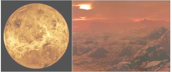 |
hidden under the clouds until radar-mapping satellites were placed in orbit around the planet. From 1990 to 1994 the Magellan space probe mapped the entire surface of Venus at high resolution by peering through the clouds with radar. It revealed a planet that has experienced a cataclysmic upheaval about 300 to 500 million years ago. There is no consensus on the cause for such global resurfacing event. Figure 07-07a shows a vast system of highlands and ridges running across much of the equator. The drawing depicts |
Figure 07-07a Venus |
a typical Venus landscape with barren, craggy rocks seen through thick carbon dioxide air under yellowish clouds, containing sulfuric acid droplets. |
 |
Phosphine is a constituent of the Earth's atmosphere at very low concentration probably from decaying organic matter. It is also found in Jupiter's atmosphere with the source in the planet's hot and high pressure interior. Venus lacks such high energy condition to form phosphine, thus another explanation for its presence is required. The paper announcing the discovery suggests that the phosphine "could originate from unknown photochemistry or geochemistry, or, by analogy with biological production of PH3 on Earth, from the presence of life". In addition, the process would have to be replenished as the phosphine would not persist in the Venusian atmosphere; being subject to ultraviolet radiation, it would eventually be consumed by water and carbon dioxide. For this reason phosphine has been proposed to be a usable biosignature for astrobiology. PH3 is associated with anaerobic ecosystems on Earth, which may be indicative of life on anoxic exoplanets. |
Figure 07-07aa |
Figure 07-07aa shows the Venusian thick clouds in two bands of ultraviolet light. It is taken by the Venus-orbiting Akatsuki, a Japanese robotic satellite that has been orbiting the cloud-shrouded world since 2015. |
 |
 |
 |
|
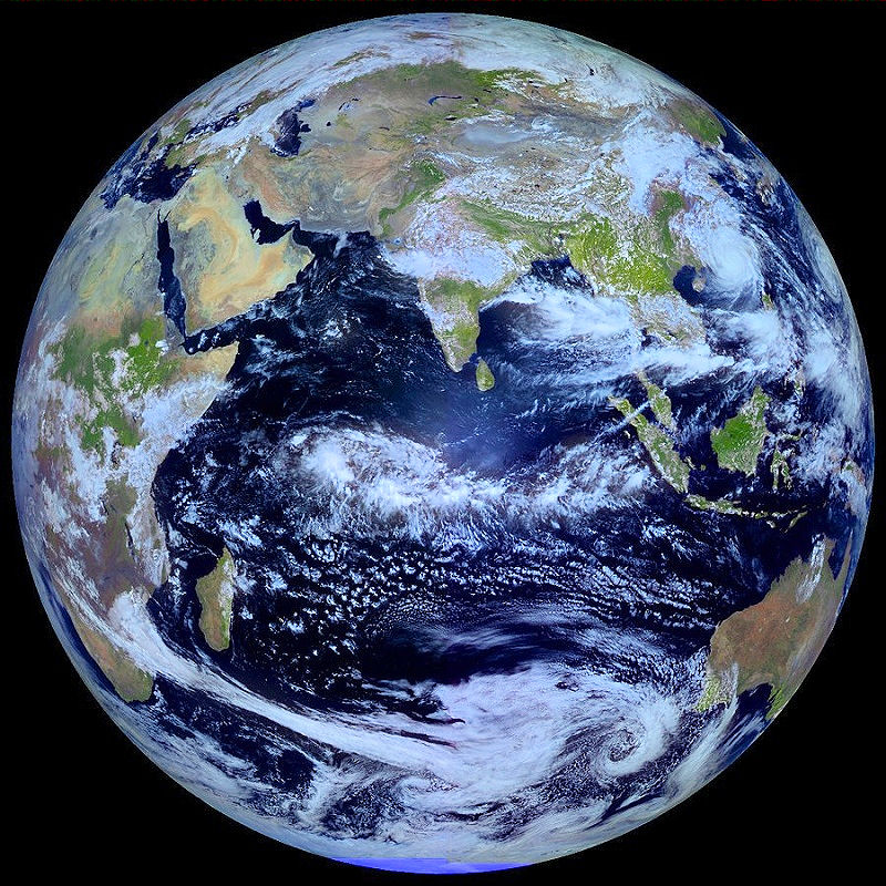
Figure 07-07b Earth, New World |
Figure 07-07c Earth, Old World [view large image] |
Figure 07-07d Earth, Whole [view large image] |
 |
 |
Earth's equator. The impact may also have been responsible for inducing the tilt in the Earth's rotational axis. Serenity had since been restored to the system. The Moon is the most luminous celestial body at night inspiring many folklores in different cultures. Actually, the Moon's appearance changes nightly. Figure 07-08b shows the changing face during a lunation, a complete lunar cycle. The Moon always keeps the same face toward the Earth. Its apparent size changes slightly, though, and a slight wobble called a libration is discernable as it progresses along its elliptical orbit. During the cycle, sunlight reflects from the Moon at different angles, and so |
Figure 07-08a Impact Theory |
Figure 07-08b Lunar Phases [view animation, and chart] |
illuminates different features differently. A full lunation takes about 29.5 (solar) days, just under a month. Hit STOP button of the browser or Esc to see a particular phase, reload to see animation again. |
 |
 |
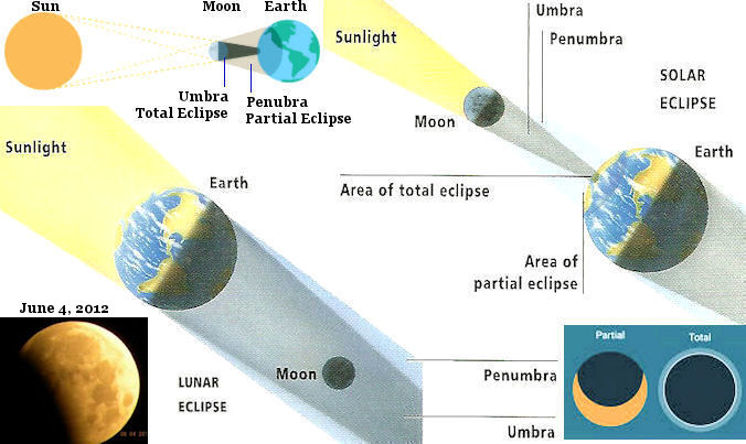
called the nodes (N1, N2 in Figure 07-08d). Eclipse would occur only when the Sun-Moon-Earth or Sun-Earth-Moon (~ 15 days later) line up at the node(s) roughly in a straight line. Such occurrence happens about once every six months. |
Figure 07-08c Solar & Lunar Eclipses [view large image] |
Figure 07-08d Lunar Orbit in Helio- and Geo-centric Coordinates [view large image] |
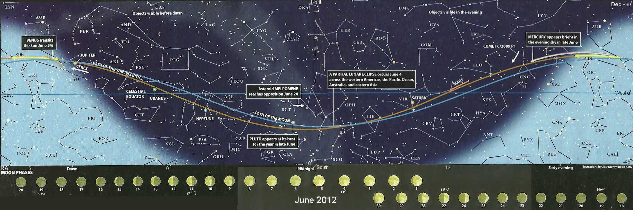 |
The occurrence of eclipses can be explained even better by considering the paths of the Moon (blue) and Sun (red) as shown in Figure 07-08e. The map depicts the mid-latitude sky with the summer night in the middle and the day light on both sides. It shows the lunar phases for the month of June 2012. The Moon in the sky can be located by drawing a line from the phase picture for the day straight up to the blue curve. The time of its appearance is specified by the corresponding RA |
Figure 07-08e Sun Moon Paths in June 2012 [view large image] |
(Right Ascension) in unit of hour with a range of 24 hours. Actually, the night sky progressively moves eastward with each passing day at a rate of about 4 min/day. Its size also changes according to the four seasons. |
 |
1. The paths of the Sun and Moon crosses at midnight June 3, 2012. However, these two celestial objects do not quite align at this point as indicated in Figure 07-08e. 2. A near alignment occurs 24 hour later causing a partial lunar eclipse. For a total lunar eclipse to occur it requires RA(moon) = RA(sun) + 12h, and Dec(moon) = -Dec(sun) in Geocentric Coordinates. Such conditions are only approximately fulfilled (see Figure 07-08f) resulting in only a partial eclipse. 3. Lunar eclipse always occurs at full moon. Simple minded consideration suggests that a solar eclipse would occur at new moon about 15 days later when the Moon is at a location between the Sun and Earth. Such event will not happen on June 18 because they will be drifting off from the N1 node (Figure 07-08d). |
Figure 07-08f Lunar Eclipse on June 4, 2012 [view large image] |
4. An annular solar eclipse did happen 15 days earlier on May 20 when the alignment was nearly perfect with RA(moon)  RA(sun), and Dec(moon) Dec(sun). RA(sun), and Dec(moon) Dec(sun). |
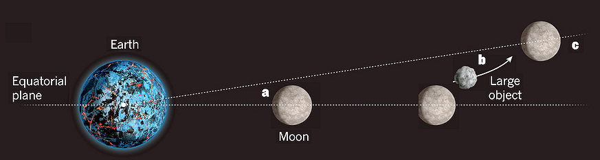 |
(a) Originally, the moon's orbit was in the Earth's equatorial plane. (b) The orbit expanded by tidal interaction with the Earth and was perturbed by large objects at the same time. (c) The population of these objects depleted over a period of about 107 years and eventually tilted the orbital plane by 5 degree. |
Figure 07-08g Lunar Orbital Tilt |
Such interpretation also explains the relatively higher abundance of platinum and gold in the Earth's upper layer. It was delivered by a few impactors from those intruding objects according to the above scheme. See "The Moon's Tilt for Gold". |
 << see "All about the Moon"
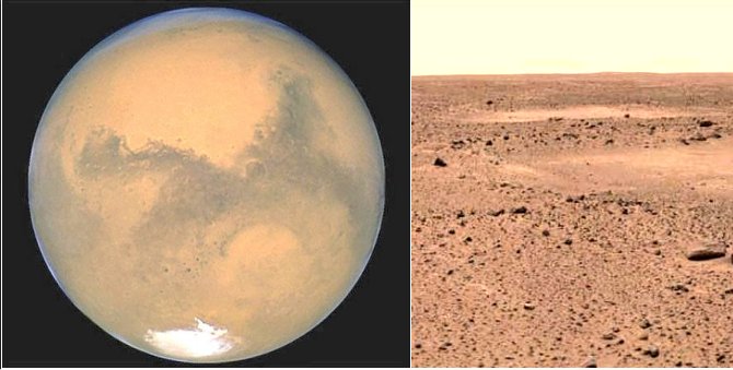 |
Figure 07-09a Mars |
 |
 |
the Martian meteorite ALH84001 (Figure 07-09b), which consists of rocks that are 4.5 billion years old. It may have subsequently been permeated by water about 3.6 billion years ago. These time scales coincide closely with the formation of the Earth and the origin of life on Earth. Figure 07-09c shows fossil imprints of filamentous bacteria (with a diameter of several 10-5 cm), whose cells have been preserved between layers of sedimentary rocks 3.465 billion years old in north western Australia. The similarity between the two samples is remarkable. But eventually, the general size is determined to be many hundred times too small for a viable |
Figure 07-09b Life on Mars |
Figure 07-09c Bacteria |
living organism, and all the biosignatures in ALH84001 have been proven to be reproducible by non-biological means. Thus, the search for life on Mars remains inconclusive. |
 |
The search for life on Mars took another turn in 2004 with the report about another Martian meteorite known as Nakhla (Figure 07-09d). It fell to Earth on June 1911 in Egypt, but the analysis of its content was not initiated until 1998 following the furore over ALH84001. Examination reveals small tunnels virtually identical in size and shape to those in Earth rock bored by bacteria or archaeans. Analysis also finds carbon-rich material originated on Mars, and evidence of contact with liquid water. Critic notes that the tunnels are highly ordered in contrary to those made by Earth bacteria (see Figure 07-09d). Just as with ALH84001, settling the debate will large largely depend on whether the supposed biosignatures could have been produced by non-living processes. |
Figure 07-09d Nakhla Meteorite |
The search is now on for some abiotic way to make the tunnels. |
 |
A research team at NASA's Johnson Space Center has re-examined the ALH84001 meteorite using new technology. Their report in November 2009 indicated that there is strong evidence to support the existence of life on ancient Mars. The carbonate mineral globules containing the ALH84001 microscopic fossils (Figure 07-09e) were formed in temperature conducive to life contrary to the most strenuous counter-arguments that they were created in high-temperature environments. The Johnson team also claimed that biomorphs (a new phase coined by Richard Dawkins to describe the complex life form selected non-randomly from random mutation) have been detected in the Nakhla and Yamoto meteorites (NASA keeps a collection of 34 meteorites from Mars). |
Figure 07-09e ALH84001 Globules |
 |
and the Mars Exploration rovers has enabled scientists to arrive at the tentative conclusion that liquid water not only existed on Mars, it once covered large parts of the planet's surface, perhaps for more than a billion years. Figure 07-09g depicts the four phases of conjectural Martian history from 4.6 billion years ago to the present. Phase 1 portrays a barren landscape bombarded by huge asteroids. Phase 2 is an episode of Earth-like conditions with liquid water filling some of the basins and carving enormous river valleys. Phase 3 turns to drying out and cooling down as water freezes, seeps under the ground, or evaporates into space. Phase 4 shows the arid |
Figure 07-09f Thin Layer of Water [view large image] |
and inhospitable Mars as we see today. According to this scenario, the organsims on Mars would be rather primitive during the half billion years or so of habitable episodes |
 |
 |
as it took 3.5 billion years on Earth to develop complex life forms (in the Cambrian explosion), and another half billion years for the evolution into intelligent beings. Astronomers believe Mars's magnetic field dissipated because the planet's molten iron core solidified. The solar wind may have stripped away much of the Martian atmosphere and sent much of the water into space without the protective shield. |
Figure 07-09g Martian History [view large image] |
Figure 07-09h Watermarks on Mars |
 |
Using a spectrometer, which collects 544 colors, or wavelengths, of reflected sunlight to detect minerals on the surface of Mars, NASA's Mars Reconnaissance Orbiter observed opal on Mars (see Figure 07-09i in a 2008 report). The hydrated, or water-containing, mineral deposits are telltale signs of where and when water was present on ancient Mars. The minerals are widespread and occur in relatively young terrains with an age of about 2 billion years ago (much younger than those indicated in Figure 07-09g). The discovery has important implication to life on Mars, since the longer liquid water existed on Mars, the longer the window during which Mars may have supported life. |
Figure 07-09i Opal on Mars [view large image] |
 |
years ago. The Global Surveyor previously spotted tens of thousands of gullies that scientists believed were geologically young and carved by fast-moving water coursing down cliffs and steep crater walls. Then scientists decided to retake photos of thousands of gullies in a search for evidence of recent water activity. Two craters in the southern hemisphere that were originally photographed in 1999 and 2001 were examined again in 2004 and 2005, and the images yielded changes consistent with water flowing down the crater walls, according to the study (Figure 07-09j). |
Figure 07-09j Water on Mars [view large image] |
 |
Figure 07-09k shows an updated version of the Mars history as the result of more data and further analysis. It suggests that instead of a watery past over billions of years, there are many episodes of flooding when volcanic activities thawed frozen reserves of underground water and drove it upwards to the surface. These events may not have lasted more than a few tens of thousands of years, but they have left ample evidence of water on the surface as shown in Figure 07-09h. It is also found that the current distribution of water ice may |
Figure 07-09k Mars History, Updated [view large image] |
be related to the wobbling of the rotational axis by the gravitational tug of Jupiter in 10 million years cycle. |
 |
 |
After a nearly 10-month voyage from Earth to Mars, the Phoenix Lander (Figure 07-09l, artist's rendition) touched down safely at the edge of the polar region (Figure 07-09m, actual image) on May 25, 2008. The area was chosen because it's suspected of harboring as much as 80% water ice by volume within just one meter of the surface. Its primary mission is to look for signs of water - liquid, ice or vapor - in the ground and atmosphere and possible traces of organic and biological material. It can measure |
Figure 07-09l Phoenix Lander [large image] |
Figure 07-09m Phoenix Landing Site [large image] |
salts, pH levels and individual chemicals, but cannot analyse the building block of life, such as proteins, or DNA. |
 |
 |
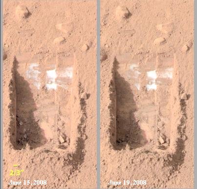
of Figure 07-09n). On June 26, 2008 members of the Phoenix Mars Mission Team revealed that the Lander has found evidence of mineral nutrients essential to life in Martian soil. The sample of Martian dirt contained several soluble minerals, including potassium, magnesium and chloride. It is the type of soil common on Earth similar to those in the backyard. The Martian soil has a very alkaline pH of between 8 to 9 suitable for growing asparagus. There is clear indication that the soil has |
Figure 07-09n Ice on Mars |
Figure 07-09o Martian Soil [view large image] |
interacted with water in the past. Figure 07-09o shows some Martian soil sprinkled from the lander's Robot Arm scoop onto a silicone substrate, which was then rotated in front of the microscope for photo taking. |
 |
As temperatures plummeted to nearly -100 oC and dust storms and clouds obscured an enfeebled sun, the Phoenix Lander finally ceased to communicate on Novermber 3, 2008 (Figure 07-09p). The mission was plagued with problems related to its instruments, it began to redeem itself toward the end when it sent a strong signal for calcium carbonate, a mineral that typically forms in the presence of water. A separate, weaker signal in the soil may indicate a different type of carbonate, or even an organic molecule. There is more work to be done on data collected during the last few months. |
Figure 07-09p End of a Mission |
 |
 |
temperature ranging from -21 oC to -96 oC. The salt is not the common table salt (NaCl) but rather in the form of perchlorate salts, which likely include magnesium and calcium perchlorate hydrates. It is conceivable that microbes could be living happily several meters underground away from the harsh ultraviolet light. Certain bacteria on Earth can exist in extremely salty and cold conditions. Several recent (2009) observations of possible mud volcanoes on Mars (Figure 07-09r) suggest the possibility that Martian microbes could be dredged up from underground lake. |
Figure 07-09q Salty Water |
Figure 07-09r Mud Volcano [view large image] |
 |
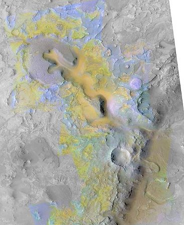
More evidences for water on Mars were gathered by NASA's Mars Reconnaissance Orbiter in mid 2008. The data have revealed that the Red Planet once hosted vast lakes, flowing rivers, and a variety of other wet environments that had the potential to support life. Study shows that vast regions of the ancient highlands of Mars, which cover about half the planet, contain clay minerals, which can form only in the presence of water. Volcanic lavas buried the clay-rich regions during subsequent, drier periods of the planet's history, but impact craters later exposed them at thousands of locations across Mars. The image in Figure 07-09s depicts ancient rivers ferried clay-like minerals (shown in green) into the |
Figure 07-09s Water on Mars, More Evidences [large image] |
lake, forming the delta. Clays tend to trap and preserve organic matter, making the delta a good place to look for signs of ancient life. |
 |
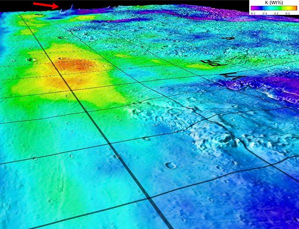 |
Figure 07-09u is a 3-D map superimposes gamma-ray data from Mars Odyssey's Gamma-Ray Spectrometer onto topographic data from the laser altimeter onboard the Mars Global Surveyor, which can detect elements buried as much as 13 inches (1/3 meter), below the surface by the gamma rays they emit. The Red-to-yellow colors on the map mark the gamma ray emitting potassium-rich sedimentary deposits in lowlands. Such great concentration of these elements in |
Figure 07-09t Glaciers on Mars [view large image] |
Figure 07-09u Sedi- |
the lowlands is interpreted as evidence of water moving them from the highlands to the lowlands. |
 |
Thus if Mars had an exclusively acidic environment during the period of 3.5 - 2.5 billion years ago as suggested in Figure 07-09g, all the carbonate minerals before this time would have been dissolved without a trace. However, an article at the end of 2008 reports that the Compact Reconnaissance Imaging Spectrometer for Mars (CRISM) has found carbonate minerals (see Figure 07-09v in colors) formed in bedrock layers more than 3.6 billion years ago. Therefore, different types of watery environments must have existed. The greater the variety of wet environments, the greater the chances one or more of them may have supported life. NASA's Phoenix Mars Lander discovered carbonates in soil samples. Researchers had previously found them in Martian meteorites that fell to Earth and in windblown Mars dust observed from orbit. However, the dust and soil could be mixtures from many areas, so the carbonates' origins have been unclear. The latest observations indicate carbonates may have formed over extended periods on early Mars in very specific locations, where future rovers and landers could search for possible evidence of past life. |
Figure 07-09v Carbonate Minerals on Mars |
Table 07-02 below summarizes observations of Martian water over the years up to 2008 and beyound. |
| Year | Observation |
|---|---|
| 1965 | Mariner 4 fly-by shows arid, crater-pocked planet lacking canals and seas |
| 1972 | Mariner 9 reveals abundant channels carved by water in ancient past |
| 1976 | Water vapour measured by Viking 2 confirms north polar cap is water ice, not frozen CO2 |
| 2000 | Mars Global Surveyor (MGS) finds young gullies - the first hint of recent water flow |
| 2003 | MGS finds fan-shaped sediment deposits indicating long-term water flow |
| 2004 | Opportunity rover finds minerals that formed in liquid water |
| 2006 | MGS detects changes in gullies, suggesting present-day water flow |
| 2008 | Phoenix becomes first probe to taste Martian ice, and detects perchlorates |
| 2008 | Mars Express radar reveals buried glaciers near equator |
| 2009 | Mars Reconnaissance Orbiter found frozen water hiding just below the surface (see below) |
| 2012 | Curiosity rover found rounded pebbles related to flowing water |
| 2015 | NASA confirms the presence of liquid water on the surface of Mars |
 |
 |
methane could also come from chemical reactions in which buried volcanic rocks rich in the mineral olivine interact with water. Another possibility is that the methane is escaping from buried clathrates, deposits of methane ice formed long ago by one of the other two mechanisms. The plumes are produced in high concen-tration (60 parts per billion) at a handful of hotspots hundreds of kilo-meters across. The methane plumes bloom and dissipate in less than a year - a fast process comparing to the time scale of |
Figure 07-09wa Methane on Mars, Local |
Figure 07-09wb Methane on Mars, Global |
sunlight degradation. Figure 07-09wb shows the global emission of methane gas in Martian summer. The data were obtained spectroscopically using large ground based telescopes. |
 |
Curiosity also found an organic compound called chlorinated methane, but it is not sure whether the carbon in the sample is from the Martian soil, or contamination from Earth, or just from cosmic dust. In short, the scientific progress is painfully slow. The answer to the question of life on Mars would have to go through a flow chart (similar to the one for the discovery of the Higgs particle). The result can be determined only from such process of elimination by observational data. A negative answer is also considered as an achievement in science, but right now there is no definite answer to this question of |
Figure 07-09x Curiosity Rover [view large image] |
whether there is life on Mars. A March 12, 2013 announcement confirms that Curiosity has found an environment conducive to life by analyzing the drilled rock sample (see insert in Figure 07-09x) containing neutral pH clay minerals. The water, that formed the clay, would be the kind suitable to drink by human. |
 |
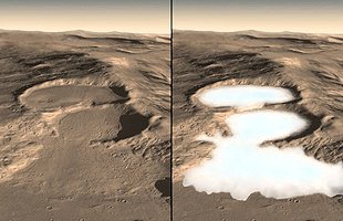
The craters did not exist in earlier images of the same sites. Some of the craters show a thin layer of bright ice atop darker underlying material (Figure 07-09y, a). The bright patches darkened in the weeks following initial observations as the freshly exposed ice vaporized into the thin martian atmosphere (Figure 07-09y, b). One of the new craters had a bright patch of material large enough for one of the orbiter's instruments to confirm it is water-ice. This ice is a relic of a more humid climate from perhaps just several thousand years ago. |
Figure 07-09y Relic of Ice [view large image] |
 |
 |
2. Martian Ocean - Other studies found that an ocean covered 1/3 of the Martian surface some 3.5 billion years ago (Figure 07-09g). Specifically they studied 52 deltas and roughly 40000 river valleys (Figure 07-09h). It is found that these geologic features are all at a similar elevation, implying that they were connected to the Martian ocean. The total amount of water is estimated to be about 1/10 of the current volume of Earth`s ocean. |
Figure 07-09za Car- bonate Mineral |
Figure 07-09zb Silicate in Martian Crater |
3. Hydrated Silicate inside Craters - Studies of 91 impact craters (Figure 07-09zb) where asteroids had exposed ancient material several miles |
 |
 |
The Mars Reconnaissance Orbiter also discovered hydrothermal mounds with mineral (such as hydrated silica - SiO2 nH2O, which can trap and preserve life by wrapping it inside - much like the amber) deposited on a volcanic cone more than 3 billion years ago (Figure 07-09zc). It could be the relic left over from a period in the Martian history when the planet began to turn dry and cold. Life flourishes in various forms around hydrothermal mounds on Earth. Martian creatures could exist similarly there clinging to life in the dying gasp. nH2O, which can trap and preserve life by wrapping it inside - much like the amber) deposited on a volcanic cone more than 3 billion years ago (Figure 07-09zc). It could be the relic left over from a period in the Martian history when the planet began to turn dry and cold. Life flourishes in various forms around hydrothermal mounds on Earth. Martian creatures could exist similarly there clinging to life in the dying gasp.
|
Figure 07-09zc Hydrated Silica on Mars [view large image] |
Figure 07-09zd Mars 2014 [view large image] |
Meanwhile in July 2104, the US Geological Survey has unveiled new Mars maps (Figure 07-09zd). See more in "New Global Geologic Map of Mars" by USGS; also "Organics on Maars". |
 |
21 September 2014. Figure 07-09de shows the October 2014 images of its atmosphere according to the atomic carbon, oxygen and hydrogen spectrographs. While the relatively heavier carbon and oxygen atoms remain in layer close to the surface, the hydrogen atoms appear to be leaving the planet's atmosphere in clumps and streams that reach about 10 Mars radii into space. The hydrogen comes from water vapour that breaks apart in the upper atmosphere meaning that part of the water is drifting into space, leaving a mostly dry, and frozen wasteland. The red color of Mars is the result of oxidizing the iron atoms on the surface (courtesy of the free oxygen from the dissociation of water). |
Figure 07-09ze Mars Atmosphere, Losting [view large image] |
 |
          |
Figure 07-09zf Missions to Mars, 21st Century |
Mission Home Page [click icon] |

 |
|
Figure 07-09zh Mars/Earth Comparison, Prebiotic [view large image] |
 |
In addition, news report on July 2024 indicated that the NASA's Perseverance rover may have just found what it was looking for on Mars billions of years ago. The rover encountered a piece of rock bearing evidences of primitive life (see Figure 07-09zh2,c) as it climbed toward the rim of the Jezero crater (see Figure 07-09zh2,a and b). On Earth, those types of features in the rocks are often associated with the fossilized record of microbes living in the subsurface. Scanning by the rover's instruments shows there are water and organic molecules within. |
Figure 07-09zh2 Life on Mars (?) [view large image] |
 |
 |
The 2024 article on "Life on Mars could be surviving in an area deep underground" pin-points an area supposed to be rich in the radioactive element thorium to produce enough energy for sustaining life (Figure 07-09zh3). Figure 07-09zh4 is a picture of life in underground Mars produced by ChatGPT. |
Figure 07-09zh3 Location |
Figure 07-09zh4 Life on Mars, ChatGPT's View [view large image] |
Here's a conversation with ChatGPT (in Italic text) on the Origin of Life : |

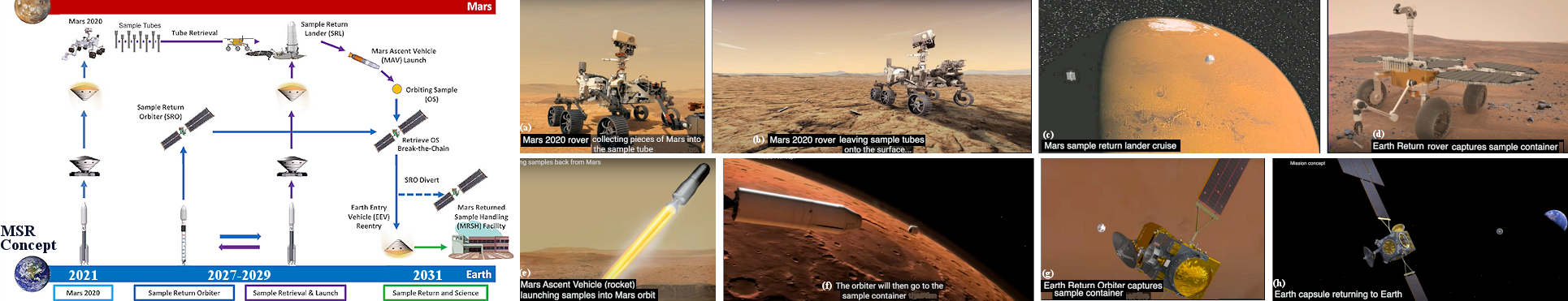 |
By early 21st century, technology has advanced to the point which would enable the return of Mars sample to Earth. In April 2018, a letter of intent was signed by NASA and ESA that may provide a basis for a Mars sample-return mission. In July 2019, a mission architecture was proposed to return samples to Earth by 2031. |
Figure 07-09zi MSR Concept |
See "Summary of MSR" |
 |
|
Figure 07-09zj |
Other nations are also planning their own MSR schemes. A Chinese version requires only one launch to achieve all the above-mentioned stages using a very powerful rocket. |
 |
 |
celestial body. Back contamination is the transfer of extraterrestrial organisms, if such exist, back to the Earth's biosphere. The Committee on Space Research (COSPAR) is tasked to set up policy for implementation of planetary protections. It meets every two years, in a gathering of 2000 to 3000 scientists to develop recommendations for avoiding interplanetary contamination. Five categories have been defined for different degrees of protections according to different kind of space missions (see Figure 07-09zk). The MSR samples will be managed under the umbrella of "Extraterrestrial sample curation". It is estimated that more than 90% of the samples can be analyzed in uncontained laboratories exempted from Sample Safety Assessment Protocol (SSAP) testing (Figure 07-09zl). |
Figure 07-09zk |
Figure 07-09zl MSR Sterilization [view large image] |
 Figure 09-zm Andromeda Strain [view large image]